Lexas Länderservice > Landkarten > Regionalkarten > Ozeanien
Responsive Ad
Karten der Inselwelt Ozeaniens
Die Inselwelt Ozeaniens wird in drei große Gebiete eingeteilt: Mikronesien, Melanesien und Polynesien.
Lage von Melanesien, Mikronesien und Polynesien. Queensland in Gelb.
![Lagekarte von Melanesien, Mikronesien und Polynesiendia.org/wikipedia/commons/thumb/2/2c/Pacific_Culture_Areas-de_incl._Queensland.png/640px-Pacific_Culture_Areas-de_incl._Queensland.png](https://upload.wikimedia.org/wikipedia/commons/thumb/2/2c/Pacific_Culture_Areas-de_incl._Queensland.png/800px-Pacific_Culture_Areas-de_incl._Queensland.png)
[ Vergrössern ]
Cultural Zones of the Pacific Ocean Basin before the arrival of the Europeans.
![File:Pacific Basin Human Geography Cultural Zones.jpg](https://upload.wikimedia.org/wikipedia/commons/6/63/Pacific_Basin_Human_Geography_Cultural_Zones.jpg)
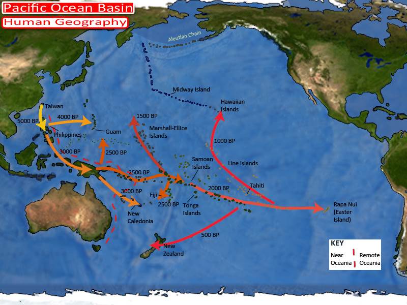
Migrations of human colonists into the Pacific Ocean basin.
![File:Pacific Basin Human Geography Migrations.jpg](https://upload.wikimedia.org/wikipedia/commons/0/07/Pacific_Basin_Human_Geography_Migrations.jpg)
Exclusive economic zones of Oceania and neighboring areas
![File:Territorial waters Oceania.png](https://upload.wikimedia.org/wikipedia/commons/thumb/3/35/Territorial_waters_Oceania.png/800px-Territorial_waters_Oceania.png)
[ Vergrössern ]